


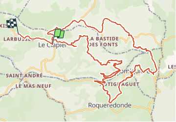
Le clapier

lablaquiere
User

Length
34 km

Max alt
843 m

Uphill gradient
824 m
Km-Effort
45 km

Min alt
514 m

Downhill gradient
832 m
Boucle
No
Creation date :
2024-03-24 15:06:01.093
Updated on :
2024-04-01 11:22:12.959
3h05
Difficulty : Very difficult

FREE GPS app for hiking
 SityTrail
IGN / Geographical institutes
SityTrail Plus
The world is yours!
About
Trail Mountain bike of 34 km to be discovered at Occitania, Aveyron, Le Clapier. This trail is proposed by lablaquiere.
Positioning
Country:
France
Region :
Occitania
Department/Province :
Aveyron
Municipality :
Le Clapier
Location:
Unknown
Start:(Dec)
Start:(UTM)
513850 ; 4853147 (31T) N.
Comments